Michael Rodrigues, Alankrita Sarkar, Maëlle Salzinger and Carola Hein
The Bauhaus, renowned for transforming 20th-century design by bridging art, industry, and architecture, has inspired the European Union to envision a 21st-century counterpart. This new Bauhaus is committed to leading a movement aligned with the European Green Deal, focusing on sustainability and social inclusion. In response to this vision, the Bauhaus of the Seas Sails proposes a continental initiative centered around the world's most fundamental natural resource: the sea.
Initiated in response to the climate crisis, the Bauhaus of the Seas Sails is an interdisciplinary, intergenerational, and interspecies initiative addressing the complexity and scale of the problem. It asserts that seas, oceans, and water bodies are the definitive global natural and shared space in the EU and the world. Established in 2022 with EU funding, the Bauhaus of the Seas Sails consortium comprises 18 academic, cultural, and territorial partners across 7 cities and regions within 4 aquatic ecosystems.
1. Bauhaus of the Seas Sails Geospatial Platform
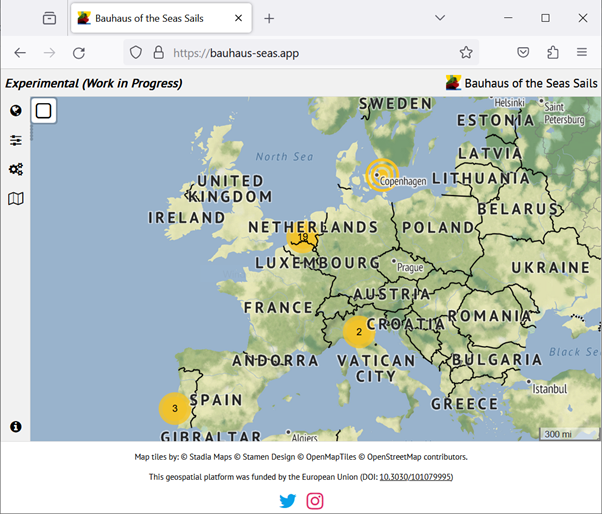
The Bauhaus of the Seas Sails geospatial platform (Figure 1) is an evolving online system that combines open-access data, spatial information on port city territories, sustainability metrics, aesthetics, inclusiveness, and narratives about the pilots taking part in the Bauhaus of the Seas Sails initiative.
This platform facilitates the analysis, visualization, and sharing of open data and project-generated information within the Bauhaus of the Seas Sails initiative, laying the groundwork for living labs and the dissemination of findings. Users can interact with multiple layers of data, gain insights, and share their experiences based on the implementation of pilot actions (“drops”). The platform currently provides a range of tools for creating engaging interactive map visualizations. With user-friendly navigation and interaction options, users can explore and analyze geospatial information seamlessly.

The platform is designed to assess the impact of “drops” (pilot actions) and “ripples” (pilot demonstrators) in various locations experiencing similar water-related transformations. By leveraging its tools and functionalities, the platform aims to bridge science, technology, education, art, and culture, in alignment with the ideals of the New European Bauhaus. The primary goal is to engage stakeholders and foster value-based discussions through interactive visualizations.
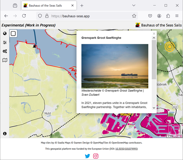
The Bauhaus of the Seas Sails geospatial platform is built on three core pillars. Firstly, it enables users to create visually appealing maps, charts, graphs, and various visual representations. These visualizations form the basis for informed discussions and contextualize the project's work across different locations, allowing users to analyze patterns, relationships, and trends within geospatial data. Secondly, the platform provides a comprehensive suite of analytical methods for performing complex spatial analyses, offering powerful tools to gain valuable insights based on geographic patterns and relationships. Lastly, through its narrative layer, the platform serves as an information-sharing repository for the Bauhaus of the Seas Sails initiative, allowing stakeholders to publicly share the effectiveness and impact of drops (pilot actions) and ripples (pilot demonstrators) (Figure 2).

The platform will feature data from the Port City Atlas book, developed by the Leiden-Delft-Erasmus PortCityFutures research group and the Faculty of Architecture & the Built Environment at TU Delft. The Port City Atlas offers a detailed cartographic representation of European port cities, exploring the complex relationships between water and land. It provides valuable insights into the built environment of port city regions, highlighting their unique characteristics.
By focusing specifically on the presence and influence of ports, the Port City Atlas Layer establishes a foundation for understanding and analysing the vital challenges faced within these dynamic regions. It explores the multifaceted aspects of infrastructure, built structures, and institutions situated at the intersection of sea and land. This perspective allows for a holistic comprehension of the complexities involved in the development and sustainability of port city territories while acting as a base layer for other data that will be made available on the platform.
2. Platform's goals
The geospatial platform aims to provide a foundation for understanding and analyzing the critical challenges faced by port-city territories. It allows for the exploration of diverse aspects of infrastructure, built structures, and institutions situated at the convergence of sea and land. This perspective fosters a comprehensive understanding of the complexities involved in the development and sustainability of these intricate regions.
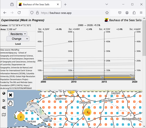
The geospatial platform is designed to establish a solid foundation for living labs and the dissemination of findings. It aims to bridge the gap between science, technology, education, art, and culture, creating a cohesive connection among these fields. By engaging stakeholders, the platform facilitates value-based discussions through interactive visualizations (Figure 3), encouraging active participation and collaboration. Additionally, it serves as a repository for the findings of the Bauhaus of the Seas Sails project, ensuring that valuable insights and data are accessible for ongoing research and development.

3. Platform's key features
The platform includes a narrative layer that enables stakeholders to share stories and experiences related to the pilots. This layer is designed to capture and present qualitative insights, enriching the data with contextual narratives that offer a deeper understanding of the pilots' impact and significance.
In addition, the platform features a visualization layer that empowers users to create a range of visual representations, including maps, charts, and graphs. This functionality allows users to transform data into engaging and informative visuals, making it easier to interpret and communicate complex information.
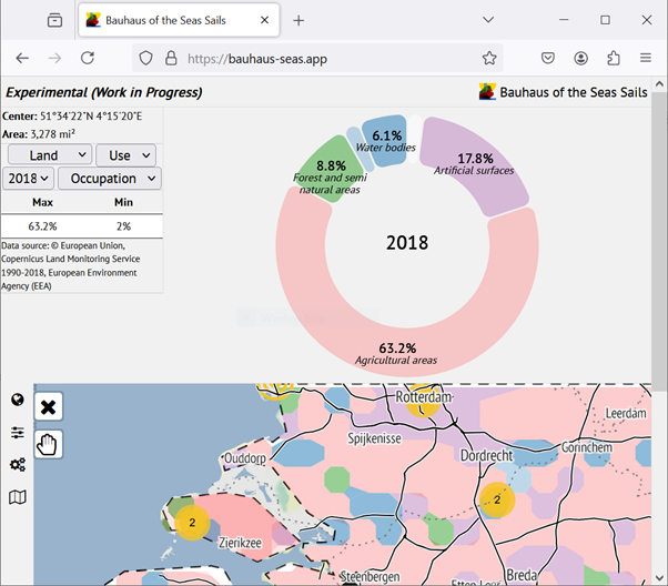
Furthermore, the platform provides an analytical layer that supports complex spatial analysis (Figure 4). This advanced feature allows users to examine geographic patterns and relationships in detail, offering valuable insights through sophisticated analytical methods. Together, these layers combine to create a comprehensive tool for exploring, understanding, and sharing data and insights from the Bauhaus of the Seas Sails initiative.

Mapping is central to the Bauhaus of the Seas Sails geospatial platform, which uses spatial data to enhance sustainable management and informed decision-making in areas where sea and land meet. By visually representing complex spatial data, mapping increases accessibility and understanding, helping stakeholders make well-informed decisions that support sustainable development. The platform seamlessly integrates spatial data from a variety of sources, including environmental, demographic, and socio-economic datasets. This comprehensive view of port-city dynamics is crucial for making informed and effective decisions.
The platform will provide a variety of thematic maps covering key dimensions like air and water quality, energy consumption, and land-use patterns. This broad thematic range ensures that decision-makers can obtain relevant information for targeted planning and policy development. Enhanced by interactive visualization techniques such as heatmaps, overlays, and time-series animations, the platform improves user experience and facilitates easier data exploration. These interactive features allow users to investigate spatial relationships and patterns within the data, offering more profound insights.
The geospatial platform demands both real-time data processing and real-time visualization capabilities. Managing data streams in real time presents challenges such as synchronizing data and ensuring near-instantaneous processing. To deliver efficient performance and quick response times, the platform must effectively handle large datasets and support high-performance processing. This is particularly important for conducting complex spatial analyses in real time or accommodating multiple concurrent users. The platform addresses these needs through a custom-built geospatial indexing method that divides geographical space into highly regular cells. Additionally, a specialized geographical search engine has been developed to enhance data query operations.
A hierarchical grid system is essential for indexing and retrieving spatial data based on geographic location in many web-based applications. This grid structure organizes geospatial data into a hierarchy of nested cells, with each level providing a different degree of detail or granularity. This hierarchical organization improves the efficiency of spatial queries across various scales, allowing for smooth exploration from broad regions to specific localized areas. By dividing geographic space into a hierarchical tessellation of regular cells, the system accelerates spatial queries and narrows the search space effectively. The hierarchical structure enables queries to quickly locate and retrieve relevant data within the specified spatial area without needing to examine every individual data point in the database. This optimization significantly reduces computational costs and enhances query performance.
The grid-based approach in the geospatial platform is essential for efficiently organizing and querying geospatial data. It provides several optimizations for spatial queries, ensuring both fast and accurate data retrieval. This method also supports zooming and Level-of-Detail (LOD) capabilities, enabling users to visualize and analyse data at various levels of granularity. Additionally, the grid-based system facilitates on-the-fly aggregation and summarization operations, offering valuable insights from geospatial data in a clear and concise manner.
One of the key benefits of hierarchical grid systems is their capability to facilitate data aggregation and summarization. The structured hierarchy enables efficient summarization by consolidating information at higher levels of the grid. Additionally, the hierarchical grid system improves data compression and storage efficiency, optimizing resource use on the server side. This approach is crucial for the geospatial platform, addressing scalability and performance issues effectively. By utilizing the hierarchical grid system, users can efficiently retrieve and analyze geospatial data across various scales. Whether for broad overviews or detailed analyses, this structure allows for organized and scalable exploration and summarization of geospatial data within the platform.
The platform's grid-based approach enhances the visualization and analysis of geospatial data by allowing users to zoom in and utilize Level-of-Detail (LOD) capabilities. The platform automatically selects the appropriate data hierarchy level for analysis based on user interactions, eliminating the need for extensive manual input. This feature streamlines the visualization experience, as the custom-built geographical search engine efficiently retrieves and displays data at various levels of detail. The system dynamically adjusts the resolution to align with the user's selected zoom level or area of interest, ensuring a seamless and responsive experience.
Conclusion
In conclusion, the Bauhaus of the Seas Sails geospatial platform is a dynamic tool designed to support sustainable management and informed decision-making in port-city territories. By integrating a diverse range of open-access geospatial data, the platform facilitates the analysis, visualization, and dissemination of information crucial for addressing the challenges of areas where sea and land intersect. Its core features—including interactive visualization, advanced analytical capabilities, and a narrative layer—enable users to explore and understand complex spatial relationships, while the hierarchical grid system optimizes data retrieval and performance. Through its seamless handling of real-time data and user-friendly interface, the platform not only enhances accessibility and insight but also fosters interdisciplinary connections and stakeholder engagement. By offering a comprehensive view of port-city dynamics and supporting scalable, detailed analyses, the Bauhaus of the Seas Sails geospatial platform stands as a vital resource for advancing sustainable development and effective decision-making in evolving coastal regions. The Bauhaus of the Seas Sails geospatial platform is available at the following address: bauhaus-seas.app
Stay connected with Bauhaus of the Seas Sails by visiting the project website and subscribing to the newsletter. Please reach out to the team if you would like to contribute or ask a question.
Carola Hein <c.m.hein@tudelft.nl> (project leader)
Michael Rodrigues <m.r.rodrigues@tudelft.nl> (geospatial platform)
Alankrita Sarkar <a.sarkar-4@tudelft.nl> (Delta pilot)
Maëlle Salzinger <m.s.salzinger@tudelft.nl> (impact assessment)
Acknowledgments
The Bauhaus of the Seas Sails is a Horizon Europe project funded by the European Union. This blog post has been written in the context of discussions in the LDE PortCityFutures research community. It reflects the evolving thoughts of the authors and expresses the discussions between researchers on the socio-economic, spatial and cultural questions surrounding port city relationships. This blog was edited by the PortCityFutures editorial team: Wenjun Feng.
